'Princess Burke' Mapping tournament
-
This mapping tournament is not like previous mapping tournaments. I'd recommend everyone to give it a thorough read. This tournament is not just about creating great content, it is also about sharing your ideas on how you tackle the creation of such great content.
You can post your submission in this forum topic until the 17th of June. There are some general guidelines to each submission:
- (1) The submission must be 10x10 and it must use the full playable area
- (2) The submission does not need to be symmetrical
- (3) The submission needs to be created for 6 players (spawn positions) in mind. You can support more or less by using the adaptive script but we'll grade it based on the default six player layout (the first six slots)
- (4) The submission needs to be new, it should not have been published at the moment the tournament starts
- (5) The submission needs to meet the vault rules
- (6) You can have only one submission
Further requirements are outlined in the
Requirementssection. If your submission does not pass the strict requirements then your submission will be disqualified. The grading of the map is explained in theGradingsections. If you have any questions or concerns then you can post them in this forum topic.And last but not least - please be aware of speculative work. We do not offer you a job here, hence this isn't speculative work. But you need to understand the value of the content that you create and share. If you manage to win this tournament then that means that you're either experienced or talented. One way or another, read the website about speculative work. It helps you understand that what you do has value and that you should be properly compensated for your time and effort when creating content professionally.
Other tournaments in this series:
-
Prizes
First place
You are rewarded with the
Grand Sculptoravatar. On top of that you have the following rewards:Additionally, the winner of the tournament receives one of the following rewards:
- A license for the Indie edition of World Machine
or
- A license for the Indie edition of Gaea
- @Prohibitorum will host a public study session on how to use Gaea in the context of FAF map making. After discussing the basics, @Prohibitorum will co-create a simple map design together with you, and go over Gaea’s workflow.
or
- A €150,- one time donation to the Oranje fonds
Second place
You are rewarded with a
Face of Factionavatar. On top of that you have the following rewards:Additionally, the runner-up of the tournament receives one of the following rewards:
- A license for the Indie edition of World Machine
or
- A license for the Indie edition of Gaea
- @Prohibitorum will host a public study session on how to use Gaea in the context of FAF map making. Two of your (pre-prepared) questions will be discussed in detail.
or
- A €150,- one time donation to the Oranje fonds
Unlike other tournaments you can not receive a direct cash pay out under any circumstance. Each prize has separate options available. The use of
oris exclusive, meaning you can't have both options. Any received license as part of a reward will be all yours to use as you see fit.The winners will be tagged in this forum post. A prize is automatically converted into a donation to the Oranje fonds if left unclaimed for one month or longer. The receipt of all donations to the Oranje fonds will be posted in this forum thread.
All the prizes are funded by myself. This first tournament is an experiment. No additional donations will be accepted. I first want to gain some experience hosting tournaments like these before I make it more complicated for myself

The mentioned study sessions will be in the FAF Discord channel, public for anyone to join. As a winner (or runner-up) you get to send questions in advance to receive prepared answers. Anyone can ask questions, but the focus will be on those questions send in advance. The session will be recorded, and be put on YouTube to preserve the knowledge that is shared.
-
Requirements
There are a lot of creative minds in this community. Those who make content all learn through trial and error. Through constantly challenging yourself. Usually the results of that are there for everyone to see. But the road that you had to take to get to those results are more difficult to find. The goal of this tournament is not so much about the results as it is about the road you took to get to the results. Some of these hard requirements reflect that.
The following rules are strict requirements. If you do not meet these requirements then your submission will be disqualified. I don't want to disqualify your submission. Please make sure you've read, understood and applied them accordingly. To list them, you have to:
- (1) Meet the functional requirements
- (2) Use either of the creative licenses on your content
- (3) Document one trial-and-error through text and images or video
- (4) Document the end results through text and images or video
1. License
Almost all of the code base of FAF is shared using an open source license. Such a license guarantees the continuity of the project. The most common license we use is the MIT license. Even some of the game code, including the navigational mesh, has that same license applied to it.
This is in contradiction with a lot of the content in the map or mod vault. Usually there is no license. As a consequence the author retains all rights and people are not allowed to make derivatives. I've always thought this to be in contradiction to the open nature of FAF. This tournament is here to help mitigate this.
All submissions require either one of the following licenses:
or
I'd highly recommend you to license it with the non-commercial license. This prevents people and companies from using your content commercially without your consent.
To license your map you need to:
- (1) Add a
LICENSE.mdfile in the map folder with the content of the license - (2) Add a reference to the license in the description of the map
A healthy consequence of this requirement is that your map can be used in other communities such as LOUD and BAR. A lot of my maps are available in the LOUD community. One of my maps is available in the BAR / Zero-k communities.
An exclusion is made to content from websites such as www.textures.com. They allow you to share the content, but they do not allow you to add a creative commons license over their content. You can read more about how to properly license those textures in a separate forum topic.
2. Documenting the road
As mentioned before, we all learn through trial and error. One requirement of this tournament is to document one such trial. It should answer the following questions to some degree:
- (1) What are you trying to accomplish?
- (2) What did you try to accomplish it, and why didn't it work?
- (3) What did you end up doing to accomplish it?
You can create this either using:
- (A) Markdown-compatible text, including images where applicable
- (B) A video that you're sharing on YouTube, available publicly
You can read more about what we'll do with this in the footnotes. There's no quality check on this requirement. You can cheese it if you want to. We hope you don't though. We hope to get a few valuable resources that people can use to learn from. A few examples available at this moment:
These examples are quite extensive , you do not need to create several videos or write several long forum posts. It is sufficient to narrow it down to one topic or insight that you'd like to share with the community.
3. Documenting the result
And as last we're asking you to add some flair to the results. Add a few screenshots and write a few sentences about what the map is about to you. The text needs to be markdown-compatible. As a few examples, see these readme files:
There's more to this tournament than just making maps. It is about sharing the knowledge to create content. It is about promoting the community and the content it creates on a weekly basis.
We'll use the documentation to create several wiki pages about the submissions. These pages include the documentation of the result, the tutorial-like documentation of (a part of) the road and the feedback of the judges. The goal is to create a hub of information that people can access for years to come.
-
Grading
This post is a draft until further notice
We'll grade your submission through four categories:
- Theme
- AI support
- Strategy
- Aesthetics
You can earn up to 10 points for each category. They are described in detail below. Each category is accompanied with examples. You can use those to get an idea what we're looking for. The categories combined can get you up to 40 points. We can give an additional 6 points for exceptional work. The total number of points that you can receive is 46. The players are sorted from most to least points.
No matter what expertise, all grading is subjective and highly depends on those who are grading. I hope these sections allow you to understand what it is that we're looking for. And I also hope that it helps you understand how one can look at a map.
-
Grading: theme category
The map should give the user the impression it is on a planet that belongs to the Aeon faction. How you achieve this is up to you. You can take inspiration from campaign maps that involve Aeon bases and settlements.

-
Grading: AI category
Reason game is unranked Amount of unique players Amount of games The game has at least one AI 40,380 384,982 We have a rough estimate that there were 70.000 unique players in 2022. More than half of those players played games with AIs - over 380.000 games in 2022 alone.
Matchmaker Month Amount of unique players Amount of games ladder1v1 December 1,689 11,102 tmm2v2 December 930 968 tmm4v4_full_share December 1,934 3,211 We took one month as an example, but even if we'd sum all the games together then the number of matchmaker games are no where near the number of games with AI. That is why there is a separate grading criteria to check for AI-compatibility. With thanks to @maudlin27 and the other AI developers there is a wiki article that has loads of tips and tricks on how the AI can perceive a map:
We highly recommend you to skim it and to, eventually, read it through. The remainder of this topic will help the default AI (the one that ships with FAF) to understand your map properly.
Hotkeys
Over the last year we've introduced various abstractions to help the AI understand a map. We'll discuss each abstraction in-depth separately. You can enable a visualizer for them using these hotkeys:
Utilities window to toy with the navigational mesh

Utilities window to show markers

Utilities window to show the reclaim grid

Navigational mesh
The navigational mesh generates a quad-tree like abstraction across a map. There are various utility functions available to the AI to sample the abstraction. Once open, the following window will pop up on your screen:
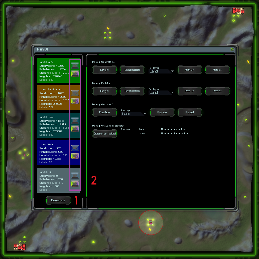
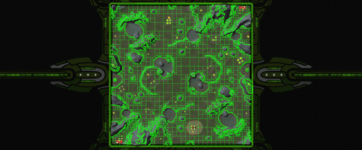
You can use this to generate the navigational mesh (1) and to visualize it (2). When you visualize it there are two options: you either visualize the layer as a whole, or the individual sub areas in the given layer.
The land layer as a whole
Individual sub areas in a layer
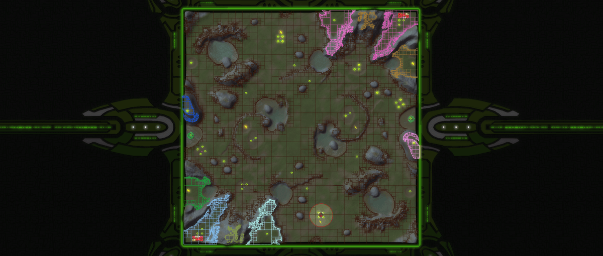
The individual sub areas allows the AI to understand where it can navigate to. It can help it understand when it needs to use a transport to navigate to an area. As a quick example: an engineer from the pink area can't possibly navigate to the brown area, therefore it needs to call in a transport.
When evaluating your map using the navigational mesh we'll take into account paths that are dangerously thin. The minimum cell size is 1x1. But not all units can navigate through that. Take the Fatboy as an example. We recommend that any path has a width of at least 8 cells for land, amphibious and the hover layer. And a width of at least 16 cells for the naval layer.
(Generated) markers
A marker is a point of interest. I've written two extensive articles about it a few years ago:
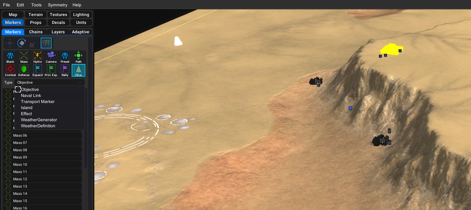
Luckily with the navigational mesh in place you no longer need to place navigational markers. At the moment we only generate expansion markers. Throughout the year we'll start generating more and more marker types, but we're not there today yet. We're asking you to populate the map with the following markers:
- Rally Point
- Naval Area
- Defensive Point
- Transport
- Combat Zone
You can read up about how they work in the linked article about AI markers. You can find all the markers in the editor:
Grids
A lot of the AI awareness works through a grid-like setup. In particular the iMAP grid that the AI uses to determine threat values.
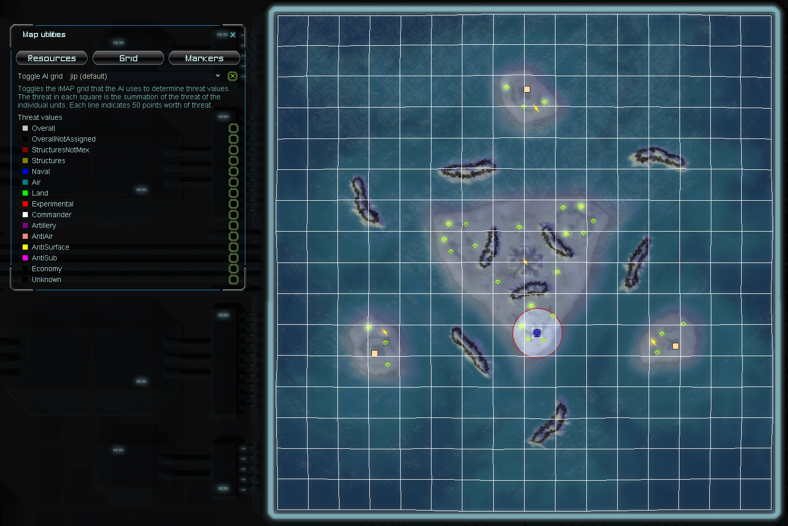
We ask you to keep this in mind where possible. As two examples:
- Reclaim spread over multiple cells means the AI can have a tough time understanding the real value, this is most important for the initial high-valued reclaim
- (Neutral) civilians over multiple cells means the AI can underestimate the real threat that the civilian base represents
-
 J Jip referenced this topic on
-
Grading: strategy category
This section boils down to what options a player has available on a map. A few common questions you can ask yourself are:
- (1) Is it clear where a player can expand to?
- (2) Is it clear where a player can send raiding parties to (resources)?
- (3) Is it clear where a player would define the rally points of its factories?
- (4) ...
You can ask these type of questions to decipher the skill range that your map can represent. Usually the more options there are the more skill it requires to utilize all the capabilities of a map.
A few examples of maps with many strategic options:
- (1v1) Open Palms
- (2v2) Adaptive Archsimkats Valley
- (2v2v2) Lily Pads
- (1v1) Forbidden Pass
- (1v1) Desert Planet II - FAF Version
- (1v1) Regor VI Highlands
- (2v2) DualGap Adaptive
A few examples of maps with limited strategic options:
- (3v3) Open Palms
- (3v3) Astro Crater
- (4v4) Goodlands
- (6v6) Dual Gap
-
Grading: aesthetics category
The look and feel of a map is as subjective as it can get. But there are some things that you can objectively confirm:
- (1) Stratum textures should not look (obviously) tiled
- (2) Decals are to be used to accentuate the heightmap and stratum textures
- (3) Unpathable bits should be well-communicated
- (4) Terrain type is to be used - it matters more than you'd think
And a few personal suggestions:
- (5) No perlin noise ocean floors
- (6) No maps that are surrounded by mountains
A few examples of maps with little to none of these issues:
- Cadmium Green
- Perrote Glacier
- Zerg Canyon
- Adaptive Mars - Mangala Fossa
- Amoor
A few examples of maps with some to many of these issues:
- Rainmakers Survival (problems with 1, 2 and 3)
- Hardshield Oasis (problems with 1 and 2)
- Adaptive Islet (problems with 1, 2 and 5)
To immediately bust a possible miss conception: just because you use map-wide decals doesn't mean your map is going to look better. They are a great tool. But they are only one part of the machine and it happens to be notoriously difficult to get right.
There are many options to give you an edge in this section. You can experiment with the lighting and water settings. You can also look into subtle weather. Another useful tool is the use of color theory to find well-matching textures. And speaking of textures: you can always use custom textures found online.
-
Judges that grade
- Jip (confirmed)
- Resistance (confirmed)
- Deribus (confirmed)
- Relent0r (confirmed)
- StormLantern (confirmed)
Do not contact the judges directly. You can ask questions in this forum topic. You can find materials and guides on how to create content on the official discord. Make sure to give yourself the map author role in the #role-selection channel.
-
Reserved for Q&A
-
The
Princess Burkemapping tournament is open for submissions until the 17th of June. You can read all about it in this topic. I recommend you to read it across several days. A lot of the information is written to guide your submission.Have fun and good luck for those that compete

-
Sweet! Query; Can multiple authors contribute to a single submission?
-
@immortal-d said in 'Princess Burke' Mapping tournament:
Sweet! Query; Can multiple authors contribute to a single submission?
There will be only prize (license) available to you ( / your team) if you win. I'd like it to be clear who receives the prize when you submit your submission so that there is no discussion if you do win.
-
Very cool, thanks for taking the time to organize this!
I've got ideas already... -
I'm dusting off my microphone and setting up OBS. Time to get to work on an entry
-
how much weight is given to the aeon theme in the grading?
-
@jip said in 'Princess Burke' Mapping tournament:
You can earn up to 10 points for each category. They are described in detail below. Each category is accompanied with examples. You can use those to get an idea what we're looking for. The categories combined can get you up to 40 points. We can give an additional 6 points for exceptional work. The total number of points that you can receive is 46. The players are sorted from most to least points.
@MadMax that would be 10 points out of a total of 46. Quite a bit!
-
 F Fichom referenced this topic on
-
For those that compete - we recently found out that there was a long standing miss conception with regards to the use of textures from www.textures.com. It is also referenced in the description of the competition:
@jip said in 'Princess Burke' Mapping tournament:
An exclusion is made to content from websites such as www.textures.com. They allow you to share the content, but they do not allow you to add a creative commons license over their content. You can read more about how to properly license those textures in a separate forum topic.
What is relevant here is that textures based from PBR materials or from 3D scans can not be shared through our vault. And to be specific: we can only distribute textures that originate from photo materials. You can search for those:
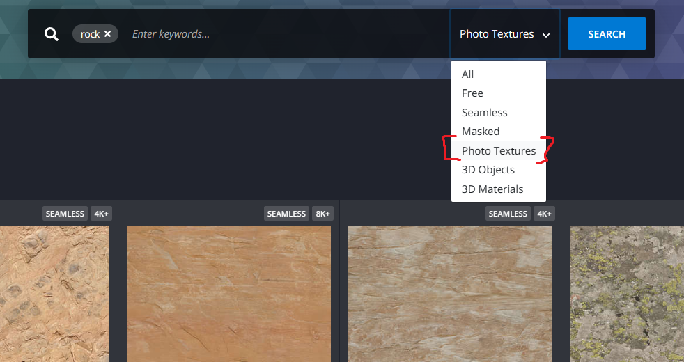
Photo materials usually lack corresponding normal maps. Luckily, there are alternatives that provide PBR textures that are more freely licensed:
Both examples only share textures licensed with CC0.
I understand that this can be frustating, especially as the deadline is set to the 17th of June. I'm willing to extend the competition by a week if people run into time issues because of this. If you do, please make yourself known in this topic before the 8th of June.
Note that maps using textures from www.textures.com in such a way that we breach their license will be disqualified for not adhering to the vault rules. You can read those here:
-
I've pinged all (veteran) mappers on Discord about my previous message. I've not received a request to extend the deadline. Therefore the deadline remains on the 17th of June.
-
submitting my map Temple of the Marxon my write up can be found here
